
 Cart
CartHistoric Maps
A valuable resource, historic maps offer a window to our nation's past. As new lands were discovered and settled, maps were drawn to help locate landmarks, differentiate between claimed properties and help others get a feel for the area. These places have changed over time and property has changed hands. These maps give us the ability to see just how much change has taken place. Changes over Time
Browse Our Selection of Historic Maps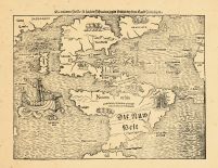
Early American maps show a much different picture of the country than the way it looks now. The city landscapes alone have changed significantly over a relatively short amount of time. By consulting the maps of areas over a specific time period, historians can chart the rate and time of growth. They can also see what buildings and developed areas were original to the time period that they are studying. Many people through the history of our nation knew the importance of maps; so many historic maps have been well preserved. This gives us a valuable resource when studying the origin of the US.
When the original explores set out to explore the "new world", they usually had a map maker with them. These historic geographic maps are the first images that we have of the shape of the land that was to become our nation. These maps were provided for the financial backers of these expeditions (usually governments) to show what their investment purchased.
Maps Show World View
Maps that date back to ancient times show what people's perception of the world around them was at that time. For many centuries, people believed that the world wasn't round. This was indicated on their maps. These historical maps show the edge of the world as a great abyss. Most civilizations weren't aware of other places outside their world. These beliefs were also indicated on their maps. As the commonly accepted view of the world changed, so did the style of map making. Map makers greatly reflect their culture in the way they made their maps.
Maps as Art
They tend to be very artistically done as well as informative. Many historic maps make great collector's items. The map makers of old were artists in their own rights. Often decorated with vibrant colors and interesting graphics, maps can be beautiful works of art. Many of the organizations that are working to preserve these maps also have rare maps for sale on their web sites. The sales from these maps often help these organizations continue their work of discovering and preserving other maps. Many auction houses often have maps for sale in auction. The serious map collector can often find treasures in flea markets and rummage sales. Often people don't realize what a valuable piece of history they have in an older map of an area.
Databases are being developed where people can view many original map images from different time periods. Members of these sites are able to access maps from all regions and time periods. With the help of digital imaging, these valuable pieces of history are available for anyone to enjoy. By preserving these historic maps, we are preserving the ability for future generations to benefit from these valuable resources.