
 Cart
CartAncient World Maps
Ancient world maps give us insight into what the ancient world looked like. Over time, many civilizations have occupied the area that we know as Europe. With the help of ancient maps, we are able to see how the area looked during each time period.
Browse Our Large Selection of Ancient World MapsAncient Europe
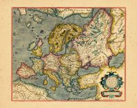
When compared to modern day maps of Europe, ancient Europe maps looked very different. Depending on the time period that the map was created, even the ancient maps vary from one another. As the empires conquered each other, the landscape of the territory changed. Each battle to conquer new regions resulted in a new map to show the expanding empire.
During the Greek empire, map makers depicted the world as a disc with an ocean encircling the disc and Greece in the center. As the scientific community of the ancient Greeks developed, the perception of what their world looked like did as well. Aristotle was the first philosopher to be credited with showing the world as round.
During the Middle Ages, map makers represented the known world as a disk of land surrounded by water. They also became more artful in design. Embellished with illustrations and other symbolism, these maps became beautiful works of art. Many landowners commissioned map makers to draw up maps of their landholdings. These give insight into how land management worked in the middle ages.
Ancient Maps
Ancient European maps aren't the only maps that showed the earth as flat, surrounded by water. Other ancient maps depict the country of origin as a central land mass surrounded by an ocean. Many cultures had maps of legendary places as well as actual landmarks. Many of these maps were central in the culture's religious practices.
Many maps were created with materials that were readily available for that culture. There have been some Babylonian maps that were carved into stone that were discovered. The Polynesian explorers that settled in the Pacific Islands used sticks tied together to form a grid pattern with palm leaves representing the wave and wind patterns. They had used shells and stones to indicate where islands were located. Later in history, early forms of paper were used and decorated with bright colorful illustrations.
Preserving Ancient Maps
Most ancient world maps have been reproduced and are available for purchase. The originals are considered artifacts and very few are actually in private collections. There are many map preserving organizations that have databases of these maps available for members to view. These libraries of maps represent a wealth of historical information. By studying a culture's map works, one can learn a tremendous amount about that cultures beliefs.
Due to technological advancements, preservation of maps is easier than it has ever been. Technology also makes great collections of these artifacts available to the general public to study and learn from. Having these maps give historians a unique look at how the culture viewed their place in the world. The preservation organizations are doing a great service by making sure these ancient world maps will be available for people to study for many generations to come.