
 Cart
CartCounty Atlas
A great source of historical information for small towns around the nation is the county atlas. These large bound editions featured maps that showed land ownership. There were also illustrations of local businesses and county offices. These books were popular in the 1800s to early 1900s. They were originally used as a marketing tool for selling books. They became popular around the time in American history when smaller towns were beginning to flourish. They were a way to list achievements for local farmers. Slice of Local History
Browse Our Selection of County Maps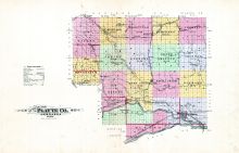
What started as a simple marketing technique has left a vast resource of historical information about small American towns. Unique to this country, these American property maps offer information about individual farms in many towns across the nation. The illustrations that are included in these atlases were often colored using stencils, as this was a less expensive way that having the colors printed on the presses.
The atlas included a county map, state map and other land owner maps. They were marketed by salesmen that went door to door. They would first go to the more prominent citizens and sell them as pre-orders for around $10. Their portraits could also be included for an additional fee. If they wanted a professional drawing of their homestead then they would have to pay an even higher fee. For many families, these books became a source of pride, often displayed on parlor tables with the family bible. For many families, the county atlas was the first time they had a glimpse of what the rest of their county looked like.
The land owner map that was included in these atlases has become an excellent source of information when researching family genealogy. These original editions are very rare. Due to the combined problem of their large size and how well used they were, not very many remain in their original condition. There was a recent trend to disassemble the atlases and sell the county maps and individual pages separately.
Valuable History
The atlas map contains valuable information about the families that founded many small towns around America. Many historical restoration organizations have been able to use the information contained in the land atlas to determine the original sites of many historic structures. By utilizing these property maps, they are able to find out information that is not available in other forms of historical writings.
Many map preservation organizations have been successful in restoring and preserving these American artifacts. Many of these atlases have been put into digital databases where they are available to the general public. These databases are a valuable source of information for individuals looking for family information or restoration groups looking for historical sites.
What started as a marketing ploy has provided American historians with valuable information. Families also have a valuable resource for researching their genealogy. One of the most valuable sources of information about American towns from the 1800s and early 1900's, the county atlas offers unmatched historical information useful for many applications.