
 Cart
Cart
|
ITEM #SP1266
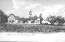
SA1656 - Village view of Canterbury village. Identified on the front. Same as SA 1657.From Winterthur Shaker Photograph and Post Card Collection 1851 to 1921c Published by Various in 1851 to 1921c |
 Buy »
Buy »Community: Canterbury, NH; Family: Unattributed; Place: Unattributed; Date: Unattributed; Type: Postcard - Color postcard; Publisher: Cody Bros., Canterbury, NH; Subject(s): Buildings--New Hampshire--Canterbury, N/A; Winterthur Accession # SA1656
Map Information
Full Title: SA1656 - Village view of Canterbury village. Identified on the front. Same as SA 1657.
Full Atlas Title: Winterthur Shaker Photograph and Post Card Collection 1851 to 1921c
Location 1:
Location 2:
Publish Date: 1851 to 1921c
Publisher: Various
Number Maps in the Atlas: 944
Map Original Width: 5.45"
Map Original Height: 3.52"
Item Number: SP1266
Collection: Historic Map Works Rare Historic Maps Collection
Image Quality: High quality scan of original that is perfect for printed fine-art quality reproduction.
Source Institution:

© The Henry Francis du Pont Winterthur Museum, Inc., Winterthur, DE, USA.
Souce Media:
Original Document
© The Henry Francis du Pont Winterthur Museum, Inc., Winterthur, DE, USA.
Souce Media:
Original Document
| This antique map (SA1656 - Village view of Canterbury...) and atlas (Winterthur Shaker Photograph and Post Card Collection 1851 to 1921c) are part of the Historic Map Works, Residential Genealogy™ historical map collection, the largest digital collection of rare, ancient, old, historical, cadastral and antiquarian maps of its type. We currently have over 1,662,956 images available online. You can read about the collection or browse the entire collection. |