
 Cart
Cart
|
ITEM #SP1370
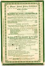
82x242 back cover - Military and Patriotic Illustrated Songs Series 1 Back CoverFrom Civil War Songs from Winterthur's Magnus Collection Published by Charles Magnus in 1861 to 1865 |
 Buy this Map »
Description: Booklet opens to six songs (each are catalogued individuallyas 82x242a-g). Color images. Ad on the back cover advertising army guides and views of hospitals and camps.; Format: Songsheet; Date: [1861-1865]; Artist / Engraver: Charles Magnus; Other names: n/a; Subject 1: Magnus, Charles, 1826-1900; Printers-New York (State)-New York; Subject 2: Lithography, American-19th century; Music printing-United States; Patriotic music; Winterthur Accession # : 82x242 back cover
Map Information
Full Title: 82x242 back cover - Military and Patriotic Illustrated Songs Series 1 Back Cover
Full Atlas Title: Civil War Songs from Winterthur's Magnus Collection
Location 1:
Location 2:
Publish Date: 1861 to 1865
Publisher: Charles Magnus
Number Maps in the Atlas: 49
Map Original Width: 5.51"
Map Original Height: 8.04"
Item Number: SP1370
Collection: Historic Map Works Rare Historic Maps Collection
Image Quality: High quality scan of original that is perfect for printed fine-art quality reproduction.
Source Institution:

© The Henry Francis du Pont Winterthur Museum, Inc., Winterthur, DE, USA.
Souce Media:
Original Document
© The Henry Francis du Pont Winterthur Museum, Inc., Winterthur, DE, USA.
Souce Media:
Original Document
| This antique map (82x242 back cover - Military and Pa...) and atlas (Civil War Songs from Winterthur's Magnus Collection) are part of the Historic Map Works, Residential Genealogy™ historical map collection, the largest digital collection of rare, ancient, old, historical, cadastral and antiquarian maps of its type. We currently have over 1,662,956 images available online. You can read about the collection or browse the entire collection. |