
 Cart
Cart
|
ITEM #US174140
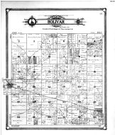
Bolivar Township, TempletonFrom Benton County 1909 Microfilm, Indiana Published by Geo. A. Ogle & Co. in 1909 |
 Buy this Map »
Maps in this atlas contain names of the property owners. For the names of residents living in the dwellings in many counties, consult atlases published by either Directory Service Company or Farm and Home Publishers when available in the database. For a full list of all published atlases of this area, browse the collection by state.


Map Information
Full Title: Bolivar Township, Templeton
Full Atlas Title: Benton County 1909 Microfilm
State: Indiana
Location 1: Unattributed
Location 2: Unattributed
Publish Date: 1909
Publisher: Geo. A. Ogle & Co.
Number Maps in the Atlas: 32
Map Original Width: 7.97"
Map Original Height: 9.39"
Item Number: US174140
Collection: Historic Map Works Rare Historic Maps Collection
Image Quality: Informational quality scan which is suitable for research use and lends itself nicely to being reproduced in our research print format.
Source Institution:

Souce Media:
Microfilm/Microfiche
Souce Media:
Microfilm/Microfiche
| This antique map (Bolivar Township, Templeton) and atlas (Benton County 1909 Microfilm) are part of the Historic Map Works, Residential Genealogy™ historical map collection, the largest digital collection of rare, ancient, old, historical, cadastral and antiquarian maps of its type. We currently have over 1,662,956 images available online. You can read about the collection or browse the entire collection. |