
 Cart
Cart
|
ITEM #SP1523
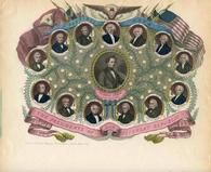
04x117.1 - Presidents of our Great Republic 1853 to 1860 ColoredFrom Historical American Illustrations from Winterthur's Magnus Collection Published by Charles Magnus in 1850 to 1899 |
 Buy this Map »
Description: A four page lettersheet with color images of Presidents Washington through Pierce. Duplicate image on lettersheet 04x069.13 and similar to lettersheet 04x069.8 but different image of Pierce.; Format: Lettersheet; Date: 1853-1860; Artist / Engraver: Charles Magnus; Other names: n/a; Subject 1: Magnus, Charles, 1826-1900; Printers-New York (State)-New York; Subject 2: Lithography, American-19th century; Presidents-United States-Portraits; Winterthur Accession # : 04x117.1
Map Information
Full Title: 04x117.1 - Presidents of our Great Republic 1853 to 1860 Colored
Full Atlas Title: Historical American Illustrations from Winterthur's Magnus Collection
Location 1:
Location 2:
Publish Date: 1850 to 1899
Publisher: Charles Magnus
Number Maps in the Atlas: 20
Map Original Width: 8.81"
Map Original Height: 7.17"
Item Number: SP1523
Collection: Historic Map Works Rare Historic Maps Collection
Image Quality: High quality scan of original that is perfect for printed fine-art quality reproduction.
Source Institution:

© The Henry Francis du Pont Winterthur Museum, Inc., Winterthur, DE, USA.
Souce Media:
Original Document
© The Henry Francis du Pont Winterthur Museum, Inc., Winterthur, DE, USA.
Souce Media:
Original Document
| This antique map (04x117.1 - Presidents of our Great ...) and atlas (Historical American Illustrations from Winterthur's Magnus Collection) are part of the Historic Map Works, Residential Genealogy™ historical map collection, the largest digital collection of rare, ancient, old, historical, cadastral and antiquarian maps of its type. We currently have over 1,662,956 images available online. You can read about the collection or browse the entire collection. |