
 Cart
Cart
|
ITEM #US61282
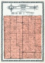
Grant Township, AdairFrom Guthrie County 1928, Iowa Published by Kenyon Company in 1928 |
 Buy this Map »


Map Information
Full Title: Grant Township, Adair
Full Atlas Title: Guthrie County 1928
State: Iowa
Location 1: Unattributed
Location 2: Unattributed
Publish Date: 1928
Publisher: Kenyon Company
Number Maps in the Atlas: 22
Map Original Width: 10.96"
Map Original Height: 15.07"
Item Number: US61282
Collection: Historic Map Works Rare Historic Maps Collection
Image Quality: High quality scan of original that is perfect for printed fine-art quality reproduction.
Source Institution:

Souce Media:
Original Document
Souce Media:
Original Document
| This antique map (Grant Township, Adair) and atlas (Guthrie County 1928) are part of the Historic Map Works, Residential Genealogy™ historical map collection, the largest digital collection of rare, ancient, old, historical, cadastral and antiquarian maps of its type. We currently have over 1,662,956 images available online. You can read about the collection or browse the entire collection. |